
Properties
Project SummaryThe Borden Lake property represents a new gold discovery associated with Timiskaming-age sediments in an underexplored part of the Kapuskasing Structural Zone. Timiskaming sediments often show a spatial association with large-scale Archean lode gold deposits such as those found in the Timmins, Kirkland Lake, Hemlo and Red Lake gold camps and thus represent an important geological indicator for the gold potential of an area. 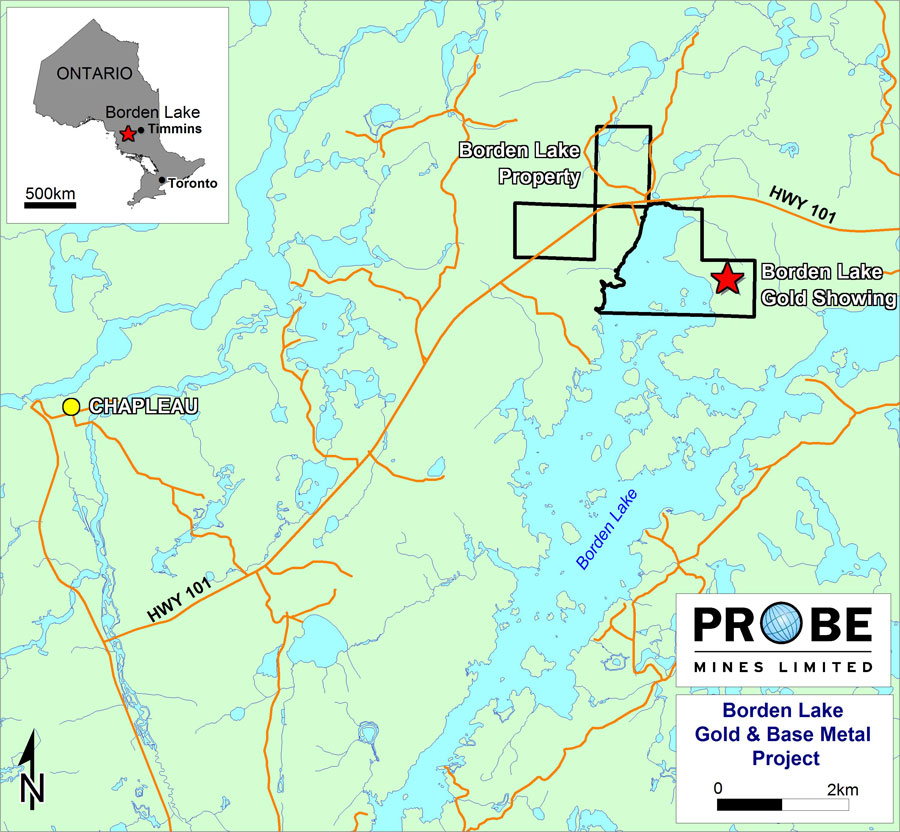 Borden Lake Location Map click on image to view enlarged The surface gold discovery has been identified over an area 150 metres long by up to 45 metres wide, hosted by a highly altered and metamorphosed suite of rocks within the volcano-sedimentary horizon. Grab samples from selected outcrop returned values of up to 3.4 g/t gold, and the property is considered to have excellent potential to host a low-grade, bulk tonnage-type of gold deposit. Limited exploration work investigating the base metal potential of the volcanic horizon was previously undertaken by Noranda. Sulphide mineralized felsic fragmental units were identified which returned anomalous base metal concentrations, suggesting good potential for hosting volcanogenic massive sulphide ("VMS") deposits. 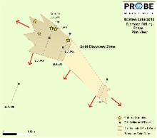 Borden Lake Sections Plan View Map click on image to view enlarged Earlier this year, Probe completed a VTEM airborne EM-magnetic survey, comprising 225 line kilometres, over the Borden Lake property. Preliminary results indicated a number of anomalies on the property, the most interesting of which consists of a 700 metre-long conductor located just south of the gold mineralization identified in outcrop. It was hoped that the EM anomaly had a genetic association with gold-mineralized outcrop and therefore implications for increased strike length, width and grade of gold mineralization. The airborne conductor is located along a horizon containing two other similar conductors which suggested the potential for an extensive mineralized zone. The first-phase drilling program was conducted in the early summer of 2010. A total of eight holes were drilled testing this surface gold showing. Thick zones of continuous gold mineralization were intersected in holes BL10-02 to BL10-07 and represent 250 metres of potential strike length along the gold zone. All six holes ended in mineralization and the true width of the mineralization is still unknown. Hole BL10-02 intersected 91 metres averaging 2 g/t Au while Hole BL10-04 was collared at the same setup as BL10-02 but drilled in the opposite direction to BL10-02 and returned a 78 metre interval averaging 0.7 g/t Au. This fanned setup has identified continuous gold mineralization over 133 metres in width (plan view) and failed to pierce the hangingwall (upper) or footwall (lower) contacts of the gold zone. Sixty metres to the southeast, Hole BL10-05 returned an 86 metre intercept grading 1 g/t Au and BL10-06 contained a 78 metre interval averaging 0.9 g/t Au. Within all of these broad mineralized intercepts at least two significant higher-grade zones were identified with intervals returning up to 5.3 g/t Au over 5 metres including samples of up to 15.5 g/t Au over one metre. Gold mineralization in the discovery area appears to be associated with a broad zone of disseminated sulphide, and is characterized by a lack of quartz veining. The horizon can be traced from airborne geophysics over approximately 1.2 kilometres within Probe's property and has been identified from surface to a vertical depth of 117 metres. The zone remains open in both directions along strike and at depth and these preliminary drill results indicate that gold grades may be increasing with depth. Perhaps more importantly, the full thickness of the zone has not been determined and there exists excellent potential for expanding the zone in every direction. BORDEN LAKE - SELECTED DRILLHOLE ASSAY INTERVALS
Highlights include: - 91m intersection averaging 2.0 g/t Au in Hole BL10-02, hole ended in mineralization - At least two higher grade zones within a broad envelope of lower grade gold, with samples returning values up to 15.5 g/t Au in higher grade zones - Grades appear to be increasing with depth - Gold mineralization intersected from surface - All holes drilled in the discovery zone ended in mineralization, total width of zone unknown - Zone is still open in all three directions, length, depth and width - Airborne geophysics indicates zone continues for over one kilometre - Only one kilometre from major highway, close to well-developed local infrastructure. The gold discovery was made within one kilometre of Highway 101, which links the towns of Chapleau and Timmins, and is approximately 15 kilometres from well-developed infrastructure in the Town of Chapleau itself. The Chapleau area has seen historic gold exploration and development activity, however, no significant work has been done in the Borden Lake area and the zone represents a significant new gold discovery in a previously unexplored area. The Company is currently reviewing all of its exploration results for the property and organizing a follow-up drilling program to further test the horizon. The initial focus of the drilling will be to determine the full width of the zone followed by further testing along strike and at depth. The Company will begin the second-phase drilling as soon as a drill is available. In addition to drilling, the Company is also planning further airborne and ground geophysical surveys on the rest of the property, with an initial focus on untested airborne targets already identified from the first VTEM program. Drill testing of satellite targets will begin once ground geophysical results have been received. Option TermsProbe has the right to earn a 100% interest in the property by making cash payments totaling $55,000 and issuing 300,000 shares over the four-year term of the agreement. The vendors maintain a 2% Net Smelter Royalty (NSR) interest, while Probe retains an option to buy back 1% of the NSR for $1,000,000. | ||||||||||||||||||||||||||||||||||||||||||||||||||||||||||||||||||||||||||||||||||||||||||||||||||||||||||||||||||||||||||||||||||||||||||||||||||||||||||||||||||||||||
